About SeaNav UK & Ireland
Explore, Plan and Navigate your boating trips in real time and outstanding high-resolution with the latest Digital Vector Marine charts derived from UKHO data covering the whole of the UK and Ireland. - Price includes all...
Explore, Plan and Navigate your boating trips in real time and outstanding high-resolution with the latest Digital Vector Marine charts derived from UKHO data covering the whole of the UK and Ireland.
- Price includes all UK & IE Charts
- FR, BE, NL, DE, DK, ES, Croatia and Portugal charts available via IAP
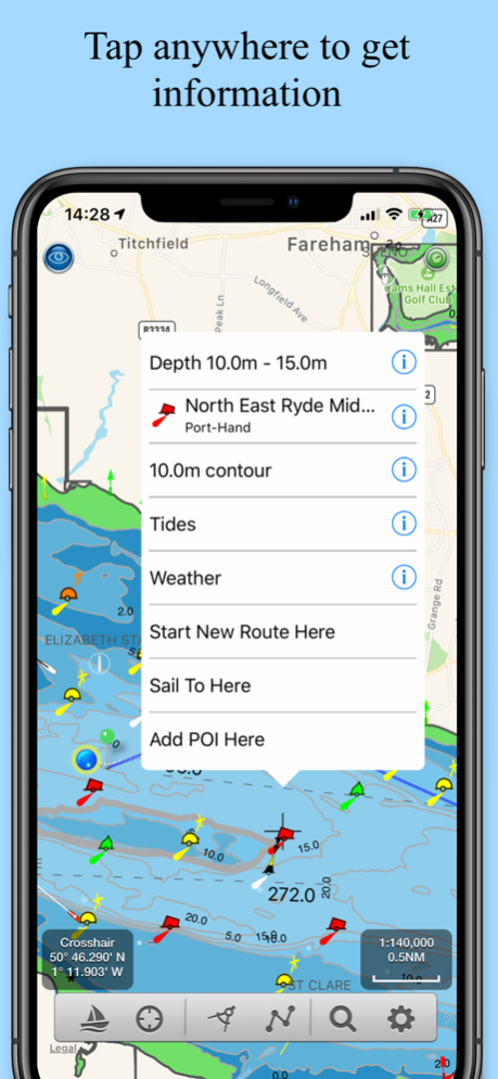
- Vector charts - buoys, lights etc. are tappable
- Seamless panning and zoom across charts
- Free Apple Watch app
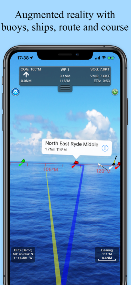
- Live Augmented Reality camera view
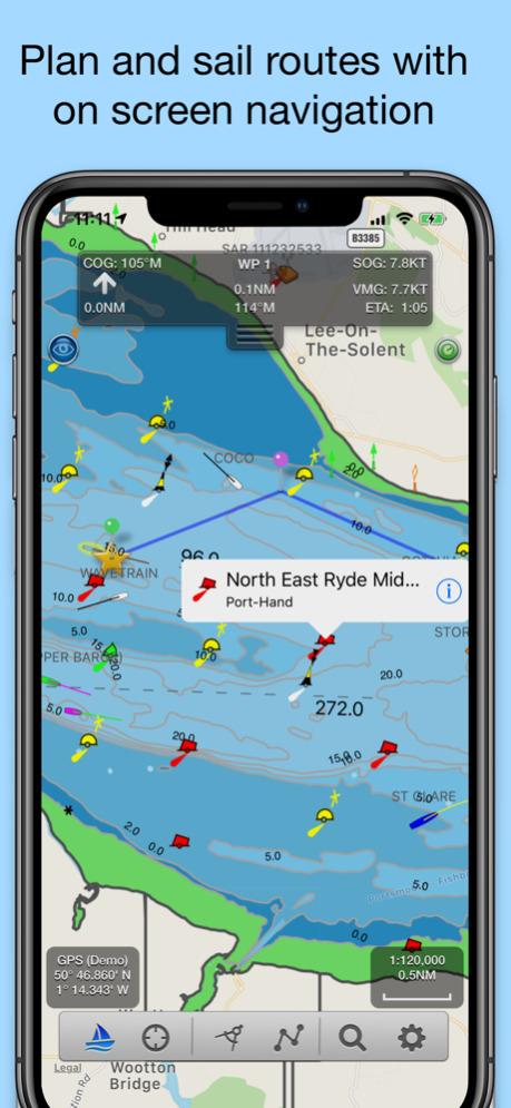
- Route Planning and real time tracking
- North and course up displays
- Offline Charts
- Route import and sharing
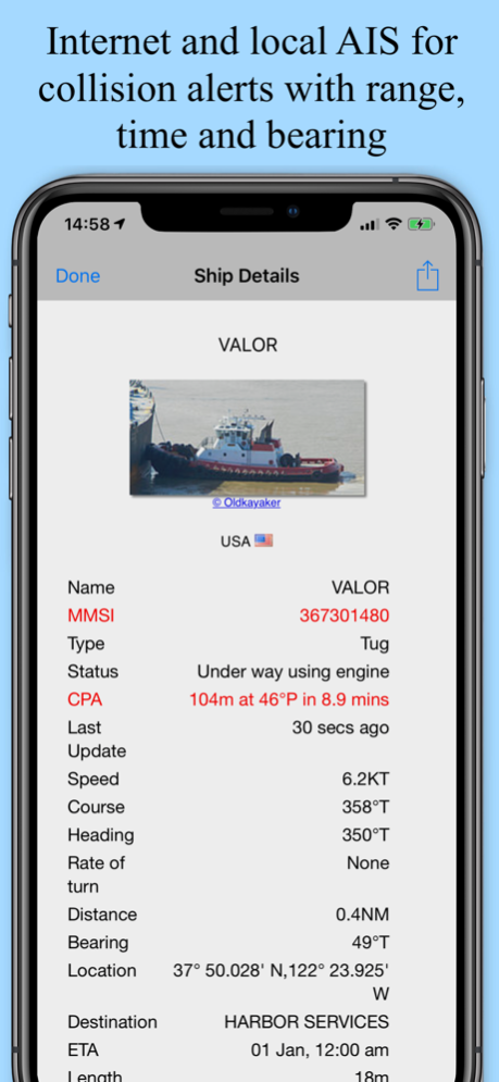
- Live AIS Ship positions - requires Boat Beacon
- Favourite Places
- Air Draft: Check your boat's clearance under bridges and cables
SeaNav works in high-resolution on your iPad, iPhone and iPod.
SeaNav uses the latest Digital Vector charts providing a wealth of benefits and advantages over traditional raster charts. Buoys, Lights, Bridges, Depth Contours, Depth Soundings, Rocks, Anchorage areas, NOAA Weather Buoys etc. are all selectable and have real time distance, bearing and detail information. Tides, moon and sun times and weather are also all available at your fingertips.
Our unique AR view mode allows you to view buoys, lights, ships, waypoints and track overlaid on your iPhone or iPad live camera view. With "AR LockOn" you can select a target on the chart and then be guided to it in the AR camera view.
In-app tools let you measure distances and bearings and record waypoints on routes to sail. When you are out at sea, the app’s Sailing HUD shows your position on the route, Course over ground (COG), Speed over ground (SOG), Vector Made Good (VMG), Estimated Time of Arrival (ETA), Distance and bearing to next Waypoint. Waypoint reached alerts, auto-routing to the next waypoint and flashing collision alerts (with Boat Beacon).
External NMEA support for AIS, Wind and Depth
Requirements:
iPhone or iPad. Optional Real time AIS, Tides and Weather information require an active internet connection.
Real-time route navigation requires a GPS location. iPhone devices and iPads with a cellular modem already have a built-in GPS, even if they do not have an active service plan. If you have a WiFi-only iPad or iPod you will need an external GPS receiver or feed to enable navigation.
Your purchase of SeaNav includes 12 months free updates to the included UK chart set. At the end of the 12 month period continued access to ongoing chart updates is available via an in-app purchase. Charts for other regions may also be added to your product via optional in-app purchase.
Our in-app purchases are 1 year subscriptions, which automatically renew at the end of the subscription period unless auto-renew is turned off at least 24-hours before the end of the current period. Payment will be charged to your iTunes Account at confirmation of purchase, and will be charged for renewal within 24-hours prior to the end of the current period. Pricing for our 1 year UK Charts update subscription is £9.99.
Subscriptions may be managed by the iTunes account holder and auto-renewal may be turned off by going to Account Settings after purchase.
No cancellation of the current subscription is allowed during active subscription period.
Please note that continued use of GPS running in the background can dramatically decrease battery life.
Terms of Use: http://seanav.net/termsofuse.php
Privacy Policy: http://seanav.net/privacy.php
Support:
[email protected]
Third Party Licenses and Notices
“THIS PRODUCT IS NOT TO BE USED FOR NAVIGATION” The use of this product for the planning and execution of passages will not meet the requirements of SOLAS
“NOTICE: Instituto Hidrográfico de la Marina (IHM) and the UK Hydrographic Office (UKHO) make no warranties or representations, express or implied, with respect to this product. The Instituto Hidrográfico de la Marina (IHM) and the UKHO have not verified the information within this product or quality assured it.”
Aug 28, 2023
Version 5.4.4
Charts for the whole of France and Portugal now available
Fix for updatable charts that have not been updated not displaying if SeaNav is not connected to the internet.
Previous Versions
Here you can find the changelog of SeaNav UK & Ireland since it was posted on our website on 2020-11-25 09:13:48.
The latest version is 5.4.4 and it was updated on 2024-04-19 19:25:48. See below the changes in each version.
SeaNav UK & Ireland version 5.4.4
Updated At: 2023-08-28
Changes: Aug 28, 2023
Version 5.4.4
Charts for the whole of France and Portugal now available
Fix for updatable charts that have not been updated not displaying if SeaNav is not connected to the internet.
SeaNav UK & Ireland version 5.4.2
Updated At: 2023-03-23
Changes: Mar 23, 2023
Version 5.4.2
Apple Watch App greatly improved Nav, Waypoint, Map ,CPA Alerts & new real time wind display
My Boat Details now lets you set the type - e.g. Sail, Pleasure, Fishing.
Own boat icon now bigger so more easily viewed and colour shows boat type.
Bridges, Shoreline and Traffic zones UI improvements
Flashing light patterns updated for South Cardinals
Realtime local wind instrument using SeaNav's Weather feed (IAP) or NMEA over Wifi
Improved Instruments for Nav (inc. Depth), Waypoints & Wind
Export tracks and routes as GPX (e.g to MFDs, Chart plotters and Navionics)
Export and import all POIs
Settings for Auto/Day/Night mode display
iOS16 ready
SeaNav UK & Ireland version 5.4
Updated At: 2022-04-13
Changes: Apr 13, 2022 Version 5.4
Apple Watch App greatly improved Nav, Waypoint, Map ,CPA Alerts & new real time wind display
Realtime local wind instrument using SeaNav's Weather feed (IAP) or NMEA over Wifi
Improved Instruments for Nav (inc. Depth), Waypoints & Wind
Export tracks and routes as GPX (e.g to MFDs, Chart plotters and Navionics)
Export and import all POIs
Settings for Auto/Day/Night mode display
iOS15 ready
SeaNav UK & Ireland version 5.3.5
Updated At: 2021-08-13
Changes: Aug 13, 2021 Version 5.3.5
Improvements to seamless chart coverage
Improvements to In App Purchase experience
Fix for charts not drawing if no internet after fresh launch of the app
SeaNav UK & Ireland version 5.3.3
Updated At: 2021-06-16
Changes: Jun 16, 2021 Version 5.3.3
Much faster chart drawing on newer Apple devices ( iPhone 9 and later and iPad 6th gen and later)
Support for iOS Dark mode - better for night time vision and use.
SeaNav iOS and its charts now works on the new MacBook M1.
Cardinal mark light patterns now displayed correctly in light details
Supports full screen width on new iPad Pros
Fix for Apple Watch app sometimes getting stuck
SeaNav UK & Ireland version 5.3
Updated At: 2021-02-18
Changes: Feb 18, 2021 Version 5.3
Tidal Streams ( rate and direction ) for UK & IE, now and predicted out to 4 days with graph (requires up to date UK & IE chart subscription)
Dark mode support for sailing at night
Cardinal mark light patterns now displayed correctly in light details
Simulation mode lets you try out sailing a route and all the navigation tools plus experience all the additional IAP features like AIS, Charts, Weather, AR mode etc. for free.
Support for iPhone X full screen - charts now go all the way to the edges.
Detailed animated weather forecast maps including wind, waves & pressure from now up to the 2 weeks ahead based on GFS model as used by NOAA and other leading Met Offices (IAP required).
Minor fixes
SeaNav UK & Ireland version 5.1
Updated At: 2019-05-24
Changes: May 24, 2019 Version 5.1
Support for iPhone X full screen - charts now go all the way to the edges.
Detailed animated weather forecast maps including wind, waves & pressure from now up to the 2 weeks ahead based on GFS model as used by NOAA and other leading Met Offices (IAP required).
Simulation mode lets you experience all the features for free.
UI improvements
SeaNav UK & Ireland version 5.1
Updated At: 1970-01-01
Changes: 2019年5月24日 Version 5.1
Support for iPhone X full screen - charts now go all the way to the edges.
Detailed animated weather forecast maps including wind, waves & pressure from now up to the 2 weeks ahead based on GFS model as used by NOAA and other leading Met Offices (IAP required).
Simulation mode lets you experience all the features for free.
UI improvements
SeaNav UK & Ireland version 5.1
Updated At: 1970-01-01
Changes: 24 mei 2019 Version 5.1
Support for iPhone X full screen - charts now go all the way to the edges.
Detailed animated weather forecast maps including wind, waves & pressure from now up to the 2 weeks ahead based on GFS model as used by NOAA and other leading Met Offices (IAP required).
Simulation mode lets you experience all the features for free.
UI improvements
Disclaimer
Official App Store Link
We do not host SeaNav UK & Ireland on our servers. We did not scan it for viruses, adware, spyware or other type of malware. This app is hosted by Apple and passed their terms and conditions to be listed there. We recommend caution when installing it.
The App Store link for SeaNav UK & Ireland is provided to you by apps112.com without any warranties, representations or guarantees of any kind, so access it at your own risk.
If you have questions regarding this particular app contact the publisher directly. For questions about the functionalities of apps112.com contact us.